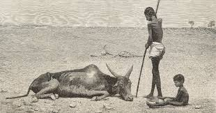
“The last of the herd” from the British newspaper The Graphic, depicting the devastating impact of the Great Famine of 1876–1878, likely the consequence of a historic El-Nino.
In the spring of 2026, suspicions of an El Niño event arose when satellites began picking up abnormal waves of warm water swells in the Pacific. Later, on June 11th, the National Weather Service issued a formal advisory announcing the continued development of the phenomenon. On September 16th, all major organizations updated their warnings, with the World Meteorological Organization (WMO) placing the likelihood of an El Niño event at 100%. Along with our certainty of its occurrence, data predictions show that this El Niño, predicted to continue well through the winter of 2027, will be unprecedented in its scale and impact.
The term El Niño was first used in the 1600s by Peruvian fishermen who noticed that the typically cold ocean waters they relied on for food would occasionally turn warm around December, driving fish from the coast and significantly diminishing their supply. Since they noticed it in December and around Christmas, they called it El Niño (little boy), referring specifically to the Christ child.
What was noticed along the Peruvian coast in the 1600s wasn’t a localized phenomenon, however. It was indeed only one of the characteristic manifestations of a much broader global event. In non-El Niño years, strong easterly trade winds push warm water westward toward Indonesia and allow cold and nutrient-rich water to accumulate by coastal South America. However, when those winds weaken, the warm water moves eastward, preventing this typical pattern of water movement. This change alone is enough to alter the behavior of weather around the world in very powerful ways. We typically experience an El Niño event every two to seven years. They tend to last for at least 9 months and up to 12 months. The most characteristic global effect is a shift in the jet stream, which brings heavy rain and flooding to the southern United States and South America, while Australia and Indonesia experience drought conditions.
Today, El Niño events are tracked by the Oceanic Niño Index (ONI), which follows a 90-day running average of sea surface temperatures in a particular slice of water in the equatorial Pacific. This average is then compared to a relatively stable baseline temperature, showing us just how much warmer than normal the water is.
As I mentioned earlier, we are now certain of the occurrence of this El Niño, and it is developing at an unprecedented pace, achieving what’s known as “super El Niño” status. Looking at past events we struggle to find an event in recorded history that parallels this current one, nonetheless it can provide useful insight into the potential scale of the consequences of such an event.
During the 1982-1983 event, the sea surface temperature average topped out at +2.2°C. With little satellite coverage at the time, scientists were largely caught off guard. The most notable impact here was destructive flooding in California, significant droughts in Australia, and widespread coral bleaching.
1997-1998 is considered the most rapidly intensifying and characteristically classic El Niño. The ONI hit +2.4°C at its peak and caused massive mudslides in the western U.S., severe ice storms in the Northeast, and a massive decline in Peruvian fish populations.
Relative to these past events, when we hear that 15 out of 26 forecasting models are projecting temperature increases of +3.0°C, it should feel particularly alarming. Adding to the concern is the fact that today’s El Niño is being recorded against decades of human-caused global warming. Since sea surface temperatures today are already higher than ever, warnings say that weather extremes, like unprecedented air temperatures and increased tropical storms, will be heavily exaggerated throughout the coming year.
Some consequences of this event are already being recorded. Decreased rainfall in Indonesia has led to devastating dry-season wildfires, and the eastern Pacific has seen far more active tropical storm development than normal. Looking into 2027, the projected consequences of this El Niño range from severe strain on food systems to extreme droughts in Australia, Indonesia, and the Amazon, to torrential floods in the southern United States, South America, and eastAfrica.
The United States Northeast will likely experience two different kinds of winters. For inland states like New York, Vermont, New Hampshire, and Maine, there is a high probability that they will experience multiple rounds of wet and dense snow. Coastal areas from Boston down to the Mid-Atlantic are likely to experience a combination of heavy rain, sleet, slush, as well as warmer air temperatures throughout the winter. Included in this latter category is the I-95 corridor and New London. That means while Northwestern Connecticut experiences snow, we will likely see heavy rain and slush. That means potentially no igloos on Tempel, sledding by the AC, or skating on the Arboretum lake.
El Niño is here, and will certainly continue to make itself known to us as the year goes on. We know broad strokes what an El Niño event looks like globally and we have some pretty solid methods for predicting its consequences. However, the specific human impact remains to be seen. In conjunction with the already erratic climate patterns we’ve been experiencing, this El Niño is shaping up to be unlike any other.